
Bavigne topographic map
Interactive map
Click on the map to display elevation.
About this map
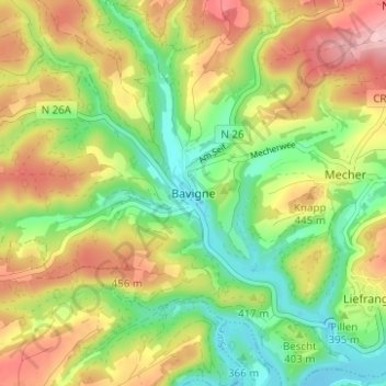
Name: Bavigne topographic map, elevation, terrain.
Location: Bavigne, Lac de la Haute-Sûre, Canton Wiltz, 9635, Luxembourg (49.90090 5.82781 49.94090 5.86781)
Average elevation: 398 m
Minimum elevation: 319 m
Maximum elevation: 496 m
Other topographic maps
Click on a map to view its topography, its elevation and its terrain.
Watrange
Luxembourg > Canton Wiltz > Lac de la Haute-Sûre
Watrange, Lac de la Haute-Sûre, Canton Wiltz, 9690, Luxembourg
Average elevation: 485 m
Harlange
Luxembourg > Canton Wiltz > Lac de la Haute-Sûre
Harlange, Lac de la Haute-Sûre, Canton Wiltz, 9655, Luxembourg
Average elevation: 451 m
Dirbach
Luxembourg > Canton Wiltz > Lac de la Haute-Sûre > Kaundorf
Dirbach, Kaundorf, Lac de la Haute-Sûre, Canton Wiltz, 9643, Luxembourg
Average elevation: 419 m
Tarchamps
Luxembourg > Canton Wiltz > Lac de la Haute-Sûre > Tarchamps
Tarchamps, Lac de la Haute-Sûre, Canton Wiltz, 9689, Luxembourg
Average elevation: 470 m