Geolocate

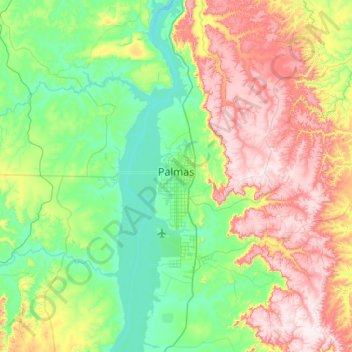
Palmas topographic map

Click on the map to display elevation.

Palmas

Palmas is one of the hottest capital cities in Brazil. During the May to September dry season, Palmas can be oppressively hot as temperatures climb into the high 30s (°C). During the October to April rainy season, it is not as hot. The heavy rains and cloud cover keep it much cooler. Palmas receives generous rainfall of about 1,300 mm. It is situated in a 'bow' valley of Rio Tocantins and surrounded by mountains from three sides; with its low elevation, 195 metres above sea level, these factors increase the humidity and discomfort of hot days.

Wikipedia (CC-BY-SA 3.0)

About this map

Name: Palmas topographic map, elevation, terrain.

Location: Palmas, Região Geográfica Imediata de Palmas, Região Geográfica Intermediária de Palmas, Tocantins, North Region, Brazil (-10.46000 -48.42293 -9.92344 -47.79327)

Average elevation: 367 m

Minimum elevation: 189 m

Maximum elevation: 711 m

Other topographic maps

Click on a map to view its topography, its elevation and its terrain.

Praia do Segredo

Brazil > Tocantins > Lajeado

Average elevation: 209 m

Campina Verde

Brazil > Tocantins

Average elevation: 271 m

Gear up for your next adventure:

🗺️Ordnance Survey Maps - Official UK maps for walking and outdoor activities
🧗Locking Carabiners - Secure gear to your pack or for light technical use
🦟Anti-Midge & Tick Repellent - Vital for hiking in the Scottish Highlands during summer
🧼Camping Hygiene Kits - Compact hygiene essentials for outdoor stays
👟Waterproof Leg Gaiters - Keep mud and water out of your boots in boggy terrain

As an Amazon Associate, this site earns from qualifying purchases at no extra cost to you.