
Seguin Township topographic map
Interactive map
Click on the map to display elevation.
About this map
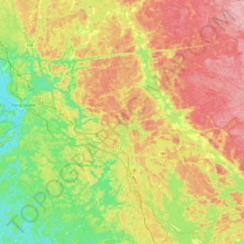
Name: Seguin Township topographic map, elevation, terrain.
Average elevation: 247 m
Minimum elevation: 172 m
Maximum elevation: 336 m
Other topographic maps
Click on a map to view its topography, its elevation and its terrain.
Emsdale
Canada > Ontario > Parry Sound District > Perry Township
Emsdale, Perry Township, Parry Sound District, Central Ontario, Ontario, P0A 1J0, Canada
Average elevation: 349 m
Black Road
Canada > Ontario > Parry Sound District > Seguin Township
Black Road, Seguin Township, Parry Sound District, Central Ontario, Ontario, P2A 2W8, Canada
Average elevation: 229 m
Georgian Bay
Canada > Ontario > Parry Sound District > Carling Township
Georgian Bay, Carling Township, Parry Sound District, Central Ontario, Ontario, Canada
Average elevation: 175 m
Byng Inlet
Canada > Ontario > Parry Sound District > Unorganized Centre Parry Sound
Byng Inlet, Unorganized Centre Parry Sound, Parry Sound District, Central Ontario, Ontario, Canada
Average elevation: 193 m
Machar Township
Canada > Ontario > Parry Sound District > Machar Township
Machar Township, Parry Sound District, Central Ontario, Ontario, P0A 1X0, Canada
Average elevation: 362 m
Sister Islands
Canada > Ontario > Parry Sound District > Carling Township
Sister Islands, Carling Township, Parry Sound District, Central Ontario, Ontario, Canada
Average elevation: 204 m