
Tangmarg topographic map
Interactive map
Click on the map to display elevation.
About this map
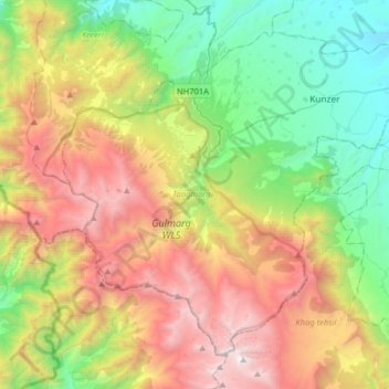
Name: Tangmarg topographic map, elevation, terrain.
Location: Tangmarg, Baramulla district, Jammu and Kashmir, India (33.90593 74.28389 34.12854 74.60424)
Average elevation: 2,776 m
Minimum elevation: 1,612 m
Maximum elevation: 4,576 m
Other topographic maps
Click on a map to view its topography, its elevation and its terrain.
Monkey Hills
India > Jammu and Kashmir > Tangmarg > Gulmarg
Monkey Hills, Gulmarg, Tangmarg, Baramulla district, Jammu and Kashmir, 193403, India
Average elevation: 2,626 m