
Lormont topographic map
Interactive map
Click on the map to display elevation.
Lormont
Lormont lies in a floodplain in the extension area of the 'Entre – Deux – Mers', to confluence the two valleys of the Dordogne and Garonne, this space is made up of recent estuarine sediments. Above 60 meters elevation, the soil consists of a limestone plateau.
About this map
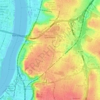
Name: Lormont topographic map, elevation, terrain.
Average elevation: 34 m
Minimum elevation: -3 m
Maximum elevation: 69 m
Other topographic maps
Click on a map to view its topography, its elevation and its terrain.
Château Coutet
France > Nouvelle-Aquitaine > Gironde > Saint-Émilion > Pourret
Average elevation: 45 m
Ancienne Abbaye de la Sauve-Majeure
France > Nouvelle-Aquitaine > Gironde > La Sauve
Average elevation: 90 m
Pont-de-la-Beauze
France > Nouvelle-Aquitaine > Gironde > Saint-André-et-Appelles
Average elevation: 48 m