Geolocate

Balangir topographic map

Click on the map to display elevation.

Balangir

Balangir is located at 20°43′N 83°29′E / 20.72°N 83.48°E / 20.72; 83.48. It has an average elevation of 383 metres (800 feet) above sea level.

Wikipedia (CC-BY-SA 3.0)

About this map

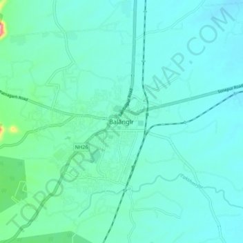
Name: Balangir topographic map, elevation, terrain.

Location: Balangir, Odisha, 767001, India (20.66415 83.45029 20.74415 83.53029)

Average elevation: 183 m

Minimum elevation: 157 m

Maximum elevation: 349 m

Gear up for your next adventure:

🎒Hiking Daypacks (20L) - Compact backpacks for day trips and technical mountain ascents
🔋Solar Power Banks - Keep your GPS and phone charged during multi-day expeditions
👕Merino Base Layers - Natural temperature regulation for cold weather hiking and camping
🧊Insulated Flasks - Keeps drinks hot or cold during hikes
👕Technical Hiking Tees - Moisture-management for high-exertion climbs

As an Amazon Associate, this site earns from qualifying purchases at no extra cost to you.