Geolocate

Siena topographic map

Click on the map to display elevation.

About this map

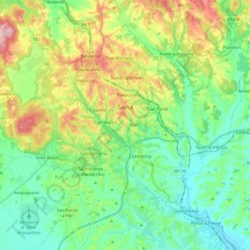
Name: Siena topographic map, elevation, terrain.

Location: Siena, Tuscany, 53100, Italy (43.24990 11.23000 43.36633 11.42856)

Average elevation: 251 m

Minimum elevation: 161 m

Maximum elevation: 451 m

Other topographic maps

Click on a map to view its topography, its elevation and its terrain.

Chiusure

Italy > Tuscany > Siena

Average elevation: 284 m

Pievasciata

Italy > Tuscany > Siena > Castelnuovo Berardenga

Average elevation: 351 m

Cetinale

Italy > Tuscany > Siena > Ancaiano

Average elevation: 393 m

Bagni San Filippo

Italy > Tuscany > Siena

Average elevation: 594 m

Modena

Italy > Tuscany > Siena > Sovicille > Recenza

Average elevation: 319 m

Bettolle

Italy > Tuscany > Siena > Sinalunga

Average elevation: 260 m

Vecciano

Italy > Tuscany > Siena > Piazze

Average elevation: 350 m

Gallina

Italy > Tuscany > Siena

Average elevation: 325 m

Ulignano

Italy > Tuscany > Siena > San Gimignano

Average elevation: 125 m

Santa Chiara

Italy > Tuscany > Siena > San Gimignano

Average elevation: 255 m

Poggio alle Lame

Italy > Tuscany > Siena > Sovicille

Average elevation: 201 m

Lilliano

Italy > Tuscany > Siena

Average elevation: 285 m

Gear up for your next adventure:

🧭Orienteering Compasses - Accurate compasses for map-based navigation
🐕Hiking Dog Harnesses - Rugged harnesses for taking your companion on mountain trails
🥾Walking Shoes - Lightweight walking shoes for countryside and coastal paths
🔦LED Camping Lanterns - Illumination for reading maps inside your tent at night
🗺️Scratch-off Peak Maps - Track your progress climbing Munros or Wainwrights

As an Amazon Associate, this site earns from qualifying purchases at no extra cost to you.