
Ürikon topographic map
Interactive map
Click on the map to display elevation.
About this map
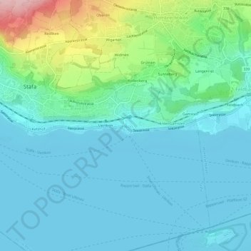
Name: Ürikon topographic map, elevation, terrain.
Location: Ürikon, Stäfa, Bezirk Meilen, Zürich, 8713, Schweiz (47.21506 8.73738 47.25506 8.77738)
Average elevation: 444 m
Minimum elevation: 402 m
Maximum elevation: 619 m
Other topographic maps
Click on a map to view its topography, its elevation and its terrain.
Ülikon
Schweiz > Zürich > Bezirk Meilen > Stäfa
Ülikon, Stäfa, Bezirk Meilen, Zürich, 8712, Schweiz
Average elevation: 488 m