
Thank you for supporting this site ❤️
Make a donation
Make a donation
Gear up for your next adventure:
As an Amazon Associate, this site earns from qualifying purchases at no extra cost to you.
Kaptembwa topographic map
Click on the map to display elevation.
Thank you for supporting this site ❤️
Make a donation
Make a donation
Gear up for your next adventure:
As an Amazon Associate, this site earns from qualifying purchases at no extra cost to you.
About this map
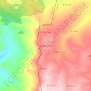
Name: Kaptembwa topographic map, elevation, terrain.
Location: Kaptembwa, Kuresoi North, Nakuru, Rift Valley, Kenya (-0.23523 35.64003 -0.19523 35.68003)
Average elevation: 2,588 m
Minimum elevation: 2,331 m
Maximum elevation: 2,758 m
Thank you for supporting this site ❤️
Make a donation
Make a donation
Gear up for your next adventure:
As an Amazon Associate, this site earns from qualifying purchases at no extra cost to you.