
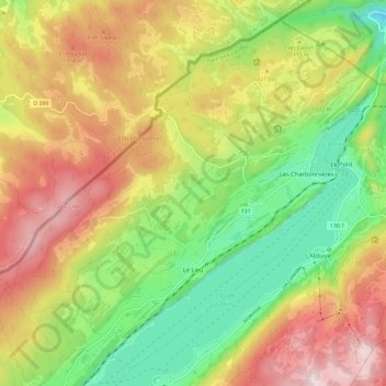
Le Lieu topographic map
Interactive map
Click on the map to display elevation.
About this map
Name: Le Lieu topographic map, elevation, terrain.
Location: Le Lieu, District du Jura-Nord vaudois, Waadt, Schweiz (46.62560 6.21903 46.69886 6.33690)
Average elevation: 1,170 m
Minimum elevation: 932 m
Maximum elevation: 1,447 m
Zu Le Lieu gehören die beiden Dörfer Le Séchey (1037 m ü. M.) am Nordostrand der Mulde des Lac Ter und Les Charbonnières (1017 m ü. M.) am Südwestufer des Lac Brenet. Ferner gehören zu Le Lieu die Siedlung Les Esserts-de-Rive (1008 m ü. M.) am Ufer des Lac de Joux und zahlreiche Einzelhöfe, die weit verstreut auf den Höhen des Petit Risoux liegen. Nachbargemeinden von Le Lieu sind Vallorbe, L’Abbaye und Le Chenit im Kanton Waadt sowie Mouthe, Sarrageois, Les Villedieu und Rochejean im angrenzenden Frankreich.
Other topographic maps
Click on a map to view its topography, its elevation and its terrain.
Provence
Schweiz > Waadt > District du Jura-Nord vaudois
Provence, District du Jura-Nord vaudois, Waadt, 1428, Schweiz
Average elevation: 971 m
Lignerolle
Schweiz > Waadt > District du Jura-Nord vaudois
Lignerolle, District du Jura-Nord vaudois, Waadt, 1357, Schweiz
Average elevation: 974 m
Le Brassus
Schweiz > Waadt > District du Jura-Nord vaudois
Le Brassus, Le Chenit, District du Jura-Nord vaudois, Waadt, 1348, Schweiz
Average elevation: 1,152 m
Dent de Vaulion
Schweiz > Waadt > District du Jura-Nord vaudois > Vaulion
Dent de Vaulion, Vaulion, District du Jura-Nord vaudois, Waadt, 1325, Schweiz
Average elevation: 1,144 m
Le Chasseron
Schweiz > Waadt > District du Jura-Nord vaudois > Bullet
Le Chasseron, Bullet, District du Jura-Nord vaudois, Waadt, 1452, Schweiz
Average elevation: 1,367 m