
Make a donation
Gear up for your next adventure:
As an Amazon Associate, this site earns from qualifying purchases at no extra cost to you.
Stave River topographic map
Click on the map to display elevation.
Make a donation
Gear up for your next adventure:
As an Amazon Associate, this site earns from qualifying purchases at no extra cost to you.
About this map
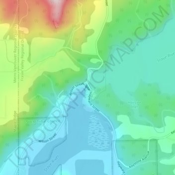
Name: Stave River topographic map, elevation, terrain.
Average elevation: 91 m
Minimum elevation: -2 m
Maximum elevation: 345 m
Make a donation
Gear up for your next adventure:
As an Amazon Associate, this site earns from qualifying purchases at no extra cost to you.
Other topographic maps
Click on a map to view its topography, its elevation and its terrain.
Chilliwack
Canada > Colombie-Britannique > District régional de Fraser Valley
Chilliwack se situe au sud-ouest de la province de la Colombie-Britannique dans le district régional de la Vallée du Fraser. La municipalité occupe la portion est des Basses-Terres Continentales, plaine correspondant à l'élargissement de la vallée du Fraser. Elle est limitée au nord par le fleuve Fraser…
Average elevation: 239 m