
Δήμος Νικολάου Σκουφά topographic map
Interactive map
Click on the map to display elevation.
About this map
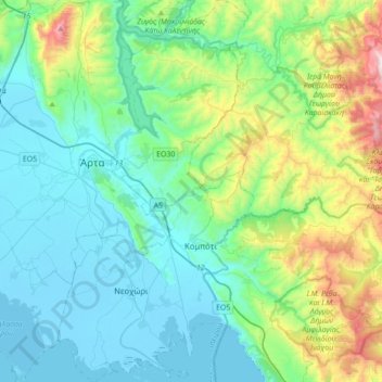
Name: Δήμος Νικολάου Σκουφά topographic map, elevation, terrain.
Average elevation: 263 m
Minimum elevation: -4 m
Maximum elevation: 1,250 m
Other topographic maps
Click on a map to view its topography, its elevation and its terrain.
Βουργαρέλι
Grèce > Épire-Macédoine occidentale > Περιφερειακή Ενότητα Άρτας
Βουργαρέλι, Δήμος Κεντρικών Τζουμέρκων, Περιφερειακή Ενότητα Άρτας, Épire, Épire-Macédoine occidentale, 470 45, Grèce
Average elevation: 861 m