
Alcoutim topographic map
Interactive map
Click on the map to display elevation.
About this map
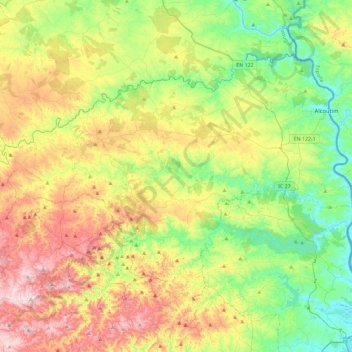
Name: Alcoutim topographic map, elevation, terrain.
Location: Alcoutim, Faro, Portugal (37.27557 -7.89684 37.52913 -7.43708)
Average elevation: 205 m
Minimum elevation: -1 m
Maximum elevation: 540 m
Other topographic maps
Click on a map to view its topography, its elevation and its terrain.
Mesquita Baixa
Portugal > Faro > São Brás de Alportel
Mesquita Baixa, São Brás de Alportel, Faro, 8150-048, Portugal
Average elevation: 218 m
Querença
Portugal > Faro > Querença, Tôr e Benafim
Querença, Querença, Tôr e Benafim, Loulé, Faro, Portugal
Average elevation: 228 m
Alportel
Portugal > Faro > São Brás de Alportel
Alportel, São Brás de Alportel, Faro, 8150-132, Portugal
Average elevation: 306 m
Gralheira
Portugal > Faro > São Bartolomeu de Messines
Gralheira, São Bartolomeu de Messines, Silves, Faro, 8375-022, Portugal
Average elevation: 155 m
Praia da Rocha
Praia da Rocha, Portimão, Faro, Portugal
Average elevation: 7 m
Budens
Portugal > Faro > Vila do Bispo > Budens
Budens, Vila do Bispo, Faro, 8650-060, Portugal
Average elevation: 74 m