
Make a donation
Gear up for your next adventure:
As an Amazon Associate, this site earns from qualifying purchases at no extra cost to you.
Ica topographic map
Click on the map to display elevation.
Make a donation
Gear up for your next adventure:
As an Amazon Associate, this site earns from qualifying purchases at no extra cost to you.
Ica
Ica has significant wine and pisco industries, annual fiestas, a museum and historic colonial churches. The climate is generally sunny and dry due to its elevation above coastal fog and mist. As of 2020, the Peruvian desert, around the Huacachina Oasis, has gotten significantly popular among tourists for sandboarding and sand buggy tours.
Make a donation
Gear up for your next adventure:
As an Amazon Associate, this site earns from qualifying purchases at no extra cost to you.
About this map
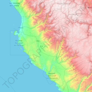
Name: Ica topographic map, elevation, terrain.
Location: Ica, Peru (-15.44378 -76.39836 -12.96493 -74.64624)
Average elevation: 1,624 m
Minimum elevation: 0 m
Maximum elevation: 5,179 m
Make a donation
Gear up for your next adventure:
As an Amazon Associate, this site earns from qualifying purchases at no extra cost to you.
Other topographic maps
Click on a map to view its topography, its elevation and its terrain.