
Laureles topographic map
Interactive map
Click on the map to display elevation.
About this map
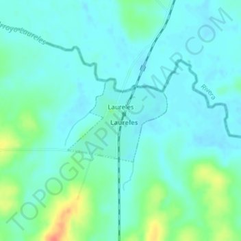
Name: Laureles topographic map, elevation, terrain.
Location: Laureles, Tacuarembó, 45020, Uruguay (-31.36817 -55.88013 -31.35884 -55.86701)
Average elevation: 143 m
Minimum elevation: 132 m
Maximum elevation: 180 m
Other topographic maps
Click on a map to view its topography, its elevation and its terrain.
San Gregorio de Polanco
San Gregorio de Polanco, Tacuarembó, 45200, Uruguay
Average elevation: 83 m
Paso de los Toros
Uruguay > Tacuarembó > Paso de los Toros
Paso de los Toros, Tacuarembó, 45100, Uruguay
Average elevation: 67 m