
Make a donation
Gear up for your next adventure:
As an Amazon Associate, this site earns from qualifying purchases at no extra cost to you.
Whanganui topographic map
Click on the map to display elevation.
Make a donation
Gear up for your next adventure:
As an Amazon Associate, this site earns from qualifying purchases at no extra cost to you.
About this map
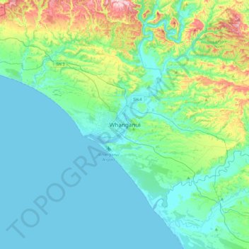
Name: Whanganui topographic map, elevation, terrain.
Average elevation: 74 m
Minimum elevation: -3 m
Maximum elevation: 404 m
Make a donation
Gear up for your next adventure:
As an Amazon Associate, this site earns from qualifying purchases at no extra cost to you.
Other topographic maps
Click on a map to view its topography, its elevation and its terrain.
Lake Wiritoa
New Zealand > Manawatu-Whanganui > Whanganui District > Whanganui > Pauri Village
Average elevation: 50 m
Kaitoke Lake
New Zealand > Manawatu-Whanganui > Whanganui District > Whanganui
Average elevation: 41 m
Lake Pauri
New Zealand > Manawatu-Whanganui > Whanganui District > Whanganui > Pauri Village
Average elevation: 57 m
Make a donation
Gear up for your next adventure:
As an Amazon Associate, this site earns from qualifying purchases at no extra cost to you.