
Make a donation
Gear up for your next adventure:
As an Amazon Associate, this site earns from qualifying purchases at no extra cost to you.
Brad topographic map
Click on the map to display elevation.
Make a donation
Gear up for your next adventure:
As an Amazon Associate, this site earns from qualifying purchases at no extra cost to you.
About this map
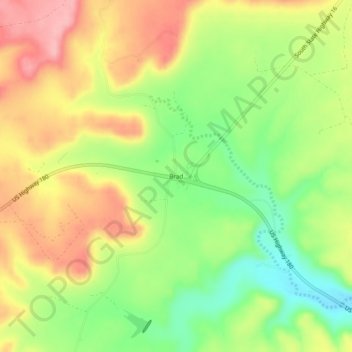
Name: Brad topographic map, elevation, terrain.
Location: Brad, Palo Pinto County, Texas, United States (32.73179 -98.52783 32.77179 -98.48783)
Average elevation: 389 m
Minimum elevation: 324 m
Maximum elevation: 454 m
Make a donation
Gear up for your next adventure:
As an Amazon Associate, this site earns from qualifying purchases at no extra cost to you.
Other topographic maps
Click on a map to view its topography, its elevation and its terrain.
Mineral Wells Fossil Park
United States > Texas > Palo Pinto County > Mineral Wells
Average elevation: 283 m
Make a donation
Gear up for your next adventure:
As an Amazon Associate, this site earns from qualifying purchases at no extra cost to you.
Make a donation
Gear up for your next adventure:
As an Amazon Associate, this site earns from qualifying purchases at no extra cost to you.