
Namborn topographic map
Interactive map
Click on the map to display elevation.
About this map
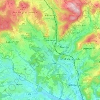
Name: Namborn topographic map, elevation, terrain.
Location: Namborn, Landkreis St. Wendel, Saarland, 66640, Deutschland (49.48551 7.12201 49.54601 7.20688)
Average elevation: 360 m
Minimum elevation: 280 m
Maximum elevation: 508 m
Other topographic maps
Click on a map to view its topography, its elevation and its terrain.
Bostalsee
Deutschland > Saarland > Landkreis St. Wendel > Nohfelden
Bostalsee, Gonnesweiler, Nohfelden, Landkreis St. Wendel, Saarland, Deutschland
Average elevation: 412 m