
Niederwil SG topographic map
Interactive map
Click on the map to display elevation.
About this map
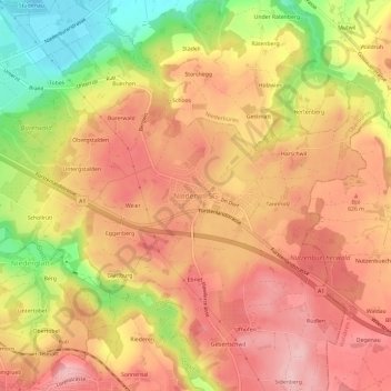
Name: Niederwil SG topographic map, elevation, terrain.
Location: Niederwil SG, Wahlkreis Wil, St. Gallen, 9203, Schweiz (47.41784 9.17622 47.45784 9.21622)
Average elevation: 591 m
Minimum elevation: 481 m
Maximum elevation: 656 m
Other topographic maps
Click on a map to view its topography, its elevation and its terrain.
Hinterbach
Schweiz > St. Gallen > Wahlkreis Wil > Stolzenberg
Hinterbach, Oberuzwil, Stolzenberg, Riggenschwil, Wahlkreis Wil, St. Gallen, 9248, Schweiz
Average elevation: 617 m
Wil (SG)
Schweiz > St. Gallen > Wahlkreis Wil
Wil (SG), Wahlkreis Wil, St. Gallen, Schweiz
Average elevation: 590 m