
Carbon County topographic map
Interactive map
Click on the map to display elevation.
About this map
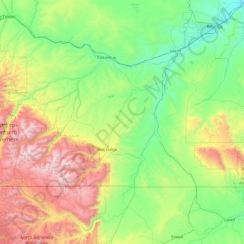
Name: Carbon County topographic map, elevation, terrain.
Location: Carbon County, Montana, VS (44.99944 -109.79869 45.63816 -108.09807)
Average elevation: 1,639 m
Minimum elevation: 916 m
Maximum elevation: 3,850 m
Other topographic maps
Click on a map to view its topography, its elevation and its terrain.
Elkhorn Hot Springs
VS > Montana > Elkhorn Hot Springs
Elkhorn Hot Springs, Beaverhead County, Montana, 59646, VS
Average elevation: 2,262 m
Glacier National Park
Glacier National Park, Sperry Lake, Flathead County, Montana, VS
Average elevation: 1,594 m