
Sint-Pietersberg topographic map
Interactive map
Click on the map to display elevation.
About this map
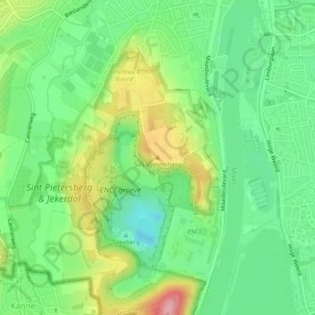
Name: Sint-Pietersberg topographic map, elevation, terrain.
Average elevation: 62 m
Minimum elevation: 10 m
Maximum elevation: 153 m
Other topographic maps
Click on a map to view its topography, its elevation and its terrain.
Itteren
Nederland > Limburg > Maastricht
Itteren, Maastricht, Limburg, Nederland, 6223 GN, Nederland
Average elevation: 46 m
Sint-Pietersberg
Nederland > Limburg > Maastricht
Sint-Pietersberg, Maastricht, Limburg, Nederland, 6212NJ, Nederland
Average elevation: 71 m
Borgharen
Nederland > Limburg > Maastricht
Borgharen, Maastricht, Limburg, Nederland, 6223 BL, Nederland
Average elevation: 51 m
Maastricht
Nederland > Limburg > Maastricht
Maastricht, Limburg, Nederland, 6211CS, Nederland
Average elevation: 101 m