
Glashütten topographic map
Interactive map
Click on the map to display elevation.
About this map
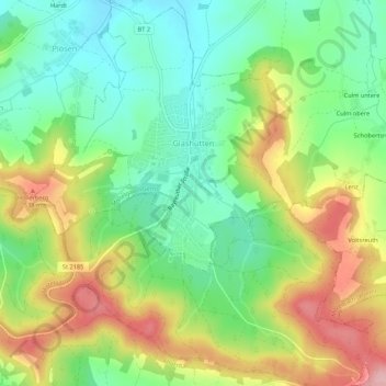
Name: Glashütten topographic map, elevation, terrain.
Average elevation: 468 m
Minimum elevation: 399 m
Maximum elevation: 569 m
Die Einöden Höhe und Poppenwiese sind mittlerweile in dem Gemeindeteil Glashütten aufgegangen.
Other topographic maps
Click on a map to view its topography, its elevation and its terrain.
Hügel
Deutschland > Bayern > Landkreis Bayreuth > Weidenberg
Hügel, Weidenberg, Weidenberg (VGem), Landkreis Bayreuth, Bayern, 95466, Deutschland
Average elevation: 521 m
Bad Berneck
Deutschland > Bayern > Landkreis Bayreuth > Bad Berneck im Fichtelgebirge
Bad Berneck, Bad Berneck im Fichtelgebirge, Landkreis Bayreuth, Bayern, 95460, Deutschland
Average elevation: 474 m