
Piz Segnas topographic map
Interactive map
Click on the map to display elevation.
About this map
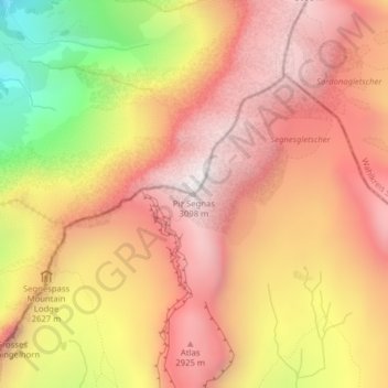
Name: Piz Segnas topographic map, elevation, terrain.
Location: Piz Segnas, Flims, Imboden, Graubünden, Schweiz (46.90773 9.23967 46.90783 9.23977)
Average elevation: 2,594 m
Minimum elevation: 1,768 m
Maximum elevation: 3,079 m
Other topographic maps
Click on a map to view its topography, its elevation and its terrain.
Grischsattel
Schweiz > Graubünden > Flims
Grischsattel, Kletterroute 25, Flims, Imboden, Graubünden, Schweiz
Average elevation: 2,461 m
Fil de Cassons
Schweiz > Graubünden > Flims
Fil de Cassons, Flims, Imboden, Graubünden, 7017, Schweiz
Average elevation: 2,346 m