
Make a donation
Gear up for your next adventure:
As an Amazon Associate, this site earns from qualifying purchases at no extra cost to you.
Exeter Township topographic map
Click on the map to display elevation.
Make a donation
Gear up for your next adventure:
As an Amazon Associate, this site earns from qualifying purchases at no extra cost to you.
Exeter Township
According to the U.S. Census Bureau, the township has a total area of 24.6 square miles (64 km2), of which 24.4 square miles (63 km2) is land and 0.2 square miles (0.52 km2) (0.77%) is water. It is drained by the Schuylkill River, which forms its natural southern boundary. While areas closer to the river are low-lying, the northwestern area of the township is in the South Mountains and exceeds 250 metres (820 feet) at its highest elevation.
Make a donation
Gear up for your next adventure:
As an Amazon Associate, this site earns from qualifying purchases at no extra cost to you.
About this map
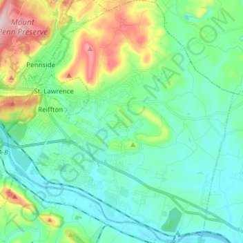
Name: Exeter Township topographic map, elevation, terrain.
Location: Exeter Township, Berks County, Pennsylvania, United States (40.26781 -75.89787 40.36240 -75.78004)
Average elevation: 113 m
Minimum elevation: 44 m
Maximum elevation: 327 m
Make a donation
Gear up for your next adventure:
As an Amazon Associate, this site earns from qualifying purchases at no extra cost to you.