
Eagle Creek topographic map
Interactive map
Click on the map to display elevation.
About this map
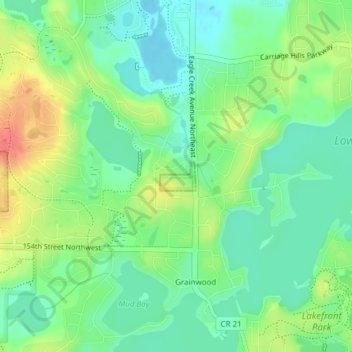
Name: Eagle Creek topographic map, elevation, terrain.
Location: Eagle Creek, Scott County, Minnesota, United States (44.72916 -93.44325 44.73142 -93.43937)
Average elevation: 284 m
Minimum elevation: 261 m
Maximum elevation: 322 m
Other topographic maps
Click on a map to view its topography, its elevation and its terrain.
Prior Lake
United States > Minnesota > Scott County
The eastern portion of Spring Lake along Scott County Road 12 is also located within the City of Prior Lake. Spring Lake, with 290 acres, but being a few minutes further out from the metro area offers similar recreational opportunities as Upper Prior Lake with a more rural character and less traffic. Spring…
Average elevation: 282 m