
Pionki topographic map
Interactive map
Click on the map to display elevation.
About this map
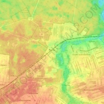
Name: Pionki topographic map, elevation, terrain.
Location: Pionki, Radom County, Masovian Voivodeship, Poland (51.43943 21.39544 51.50412 21.49964)
Average elevation: 159 m
Minimum elevation: 129 m
Maximum elevation: 175 m
Other topographic maps
Click on a map to view its topography, its elevation and its terrain.
Iłża
Poland > Masovian Voivodeship > Radom County
Iłża, gmina Iłża, Radom County, Masovian Voivodeship, 27-100, Poland
Average elevation: 204 m
Zatopolice
Poland > Masovian Voivodeship > Radom County > Zatopolice
Zatopolice, gmina Zakrzew, Radom County, Masovian Voivodeship, Poland
Average elevation: 188 m