Geolocate

Nappan topographic map

Interactive map

Click on the map to display elevation.

About this map

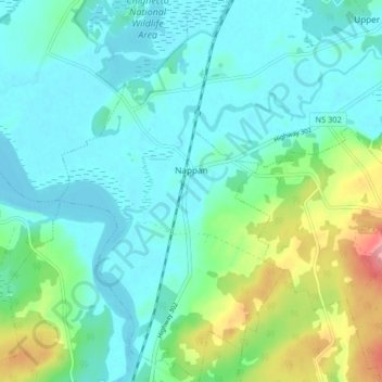
Name: Nappan topographic map, elevation, terrain.

Location: Nappan, Municipality of the County of Cumberland, Cumberland County, Nova Scotia, B0L 1C0, Canada (45.73760 -64.26825 45.79462 -64.21978)

Average elevation: 25 m

Minimum elevation: -2 m

Maximum elevation: 112 m

Other topographic maps

Click on a map to view its topography, its elevation and its terrain.

Lorneville

Canada > Nova Scotia > Municipality of the County of Cumberland

Lorneville, Municipality of the County of Cumberland, Cumberland County, Nova Scotia, B4H 3X9, Canada

Average elevation: 20 m

Rockley

Canada > Nova Scotia > Municipality of the County of Cumberland

Rockley, Municipality of the County of Cumberland, Cumberland County, Nova Scotia, B0M 1V0, Canada

Average elevation: 24 m

Wentworth Provincial Park

Canada > Nova Scotia > Municipality of the County of Cumberland > Wentworth Station

Wentworth Provincial Park, Valley Road, Wentworth Station, Wentworth, Municipality of the County of Cumberland, Cumberland County, Nova Scotia, B0M 1Z0, Canada

Average elevation: 81 m

Isle Haute

Canada > Nova Scotia > Municipality of the County of Cumberland

Isle Haute, Municipality of the County of Cumberland, Cumberland County, Nova Scotia, Canada

Average elevation: 1 m

Roslin

Canada > Nova Scotia > Municipality of the County of Cumberland

Roslin, Municipality of the County of Cumberland, Cumberland County, Nova Scotia, B0M 1P0, Canada

Average elevation: 34 m

Fenwick

Canada > Nova Scotia > Municipality of the County of Cumberland

Fenwick, Municipality of the County of Cumberland, Cumberland County, Nova Scotia, B0L 1C0, Canada

Average elevation: 79 m