
Make a donation
Gear up for your next adventure:
As an Amazon Associate, this site earns from qualifying purchases at no extra cost to you.
Tarqui topographic map
Click on the map to display elevation.
Make a donation
Gear up for your next adventure:
As an Amazon Associate, this site earns from qualifying purchases at no extra cost to you.
Tarqui
Coordinates: 3°00′49″S 79°02′04″W; Official Language: Spanish; Entity: Parish of Ecuador; Province: Azuay; Canton: Cuenca; President of the Parish Government: Galo Zhagüi; Subdivisions: 26 communities; Foundation and Parishization: October 18, 1915 (108 years old); Area: 135 km²; Average Altitude: 2628 m above. n. m.; Climate: Average annual temperatures of 12 °C to 20 °C; Watercourse: Tarqui River; Population (2010): 12,490 inhabitants, Density: 92.52 inhabitants/km²; Time Zone: ECT (UTC-5); Postal Code EC010168.
Make a donation
Gear up for your next adventure:
As an Amazon Associate, this site earns from qualifying purchases at no extra cost to you.
About this map
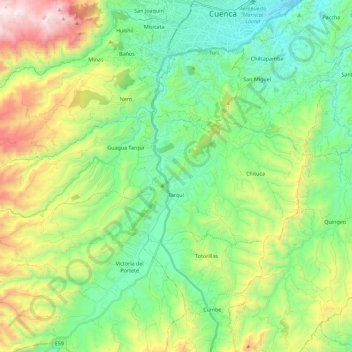
Name: Tarqui topographic map, elevation, terrain.
Location: Tarqui, Cuenca, Azuay, Ecuador (-3.04606 -79.17633 -2.95740 -78.95060)
Average elevation: 2,875 m
Minimum elevation: 2,436 m
Maximum elevation: 3,852 m
Make a donation
Gear up for your next adventure:
As an Amazon Associate, this site earns from qualifying purchases at no extra cost to you.
Other topographic maps
Click on a map to view its topography, its elevation and its terrain.
Cuenca
Cuenca, officially Santa Ana de los Ríos de Cuenca, is an Ecuadorian city, head of the canton of the same name and capital of the province of Azuay, as well as its largest and most populated city. It is crossed by the Tomebamba, Tarqui, Yanuncay and Machángara rivers, in the south-central inter-Andean region…
Average elevation: 2,973 m
Make a donation
Gear up for your next adventure:
As an Amazon Associate, this site earns from qualifying purchases at no extra cost to you.