
Thank you for supporting this site ❤️
Make a donation
Make a donation
Gear up for your next adventure:
As an Amazon Associate, this site earns from qualifying purchases at no extra cost to you.
Atalaya topographic map
Click on the map to display elevation.
Thank you for supporting this site ❤️
Make a donation
Make a donation
Gear up for your next adventure:
As an Amazon Associate, this site earns from qualifying purchases at no extra cost to you.
Atalaya
Fue fundada el 29 de mayo de 1928 y es conocida como "La Esmeralda del Ucayali". Se encuentra a una altitud de 220 m s. n. m.
Thank you for supporting this site ❤️
Make a donation
Make a donation
Gear up for your next adventure:
As an Amazon Associate, this site earns from qualifying purchases at no extra cost to you.
About this map
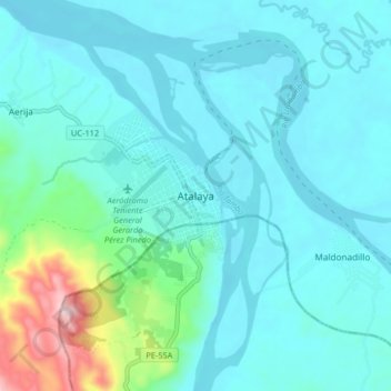
Name: Atalaya topographic map, elevation, terrain.
Location: Atalaya, Raymondi, Atalaya, Ucayali, 25201, Perú (-10.76991 -73.79488 -10.68991 -73.71488)
Average elevation: 256 m
Minimum elevation: 194 m
Maximum elevation: 616 m
Thank you for supporting this site ❤️
Make a donation
Make a donation
Gear up for your next adventure:
As an Amazon Associate, this site earns from qualifying purchases at no extra cost to you.