Geolocate

Ashley topographic map

Click on the map to display elevation.

About this map

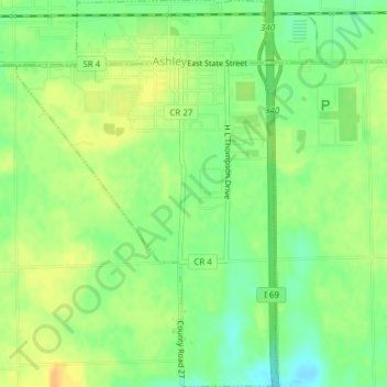
Name: Ashley topographic map, elevation, terrain.

Location: Ashley, Steuben County, Indiana, 46705, United States (41.50321 -85.08063 41.53177 -85.05488)

Average elevation: 303 m

Minimum elevation: 287 m

Maximum elevation: 317 m

Other topographic maps

Click on a map to view its topography, its elevation and its terrain.

Moonlight

United States > Indiana > Steuben County

Average elevation: 297 m

Pleasant Lake

United States > Indiana > Steuben County

Average elevation: 297 m

Lake James

United States > Indiana > Steuben County

Average elevation: 303 m

Circle Park

United States > Indiana > Steuben County > Hamilton

Average elevation: 284 m

Gear up for your next adventure:

💧Hydration Reservoirs - Convenient water bladders for hands-free drinking on the move
👕Merino Base Layers - Natural temperature regulation for cold weather hiking and camping
🥤Hiking Water Bottles - Reusable bottles for hydration on the trail
🦶Anti-Blister Balms - Protect your feet before long topographic expeditions
🧘Folding Sit Mats - Dry and warm seat for map-reading breaks on damp ground

As an Amazon Associate, this site earns from qualifying purchases at no extra cost to you.