
Le Châble topographic map
Interactive map
Click on the map to display elevation.
About this map
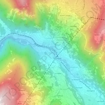
Name: Le Châble topographic map, elevation, terrain.
Location: Le Châble, Val de Bagnes, Entremont, Valais, 1934, Suisse (46.06015 7.19250 46.10015 7.23250)
Average elevation: 1,222 m
Minimum elevation: 790 m
Maximum elevation: 1,969 m
Other topographic maps
Click on a map to view its topography, its elevation and its terrain.
Le Planchamp
Suisse > Valais > Entremont > Lourtier
Le Planchamp, Lourtier, Val de Bagnes, Entremont, Valais, 1934, Suisse
Average elevation: 1,536 m
Praz-de-Fort
Praz-de-Fort, Orsières, Entremont, Valais, 2303, Suisse
Average elevation: 1,645 m
Le Revers
Suisse > Valais > Entremont > Praz-de-Fort
Le Revers, Praz-de-Fort, Orsières, Entremont, Valais, 2303, Suisse
Average elevation: 1,675 m
Champex-Lac
Champex-Lac, Orsières, Entremont, Valais, 2303, Suisse
Average elevation: 1,552 m
Col du Grand Saint-Bernard
Suisse > Valais > Entremont > Bourg-Saint-Pierre
Col du Grand Saint-Bernard, Bourg-Saint-Pierre, Entremont, Valais, 1946, Suisse
Average elevation: 2,474 m