Geolocate

Germantown topographic map

Interactive map

Click on the map to display elevation.

About this map

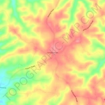
Name: Germantown topographic map, elevation, terrain.

Location: Germantown, Cheatham County, Middle Tennessee, Tennessee, United States (36.20839 -87.14917 36.24839 -87.10917)

Average elevation: 199 m

Minimum elevation: 143 m

Maximum elevation: 232 m

Other topographic maps

Click on a map to view its topography, its elevation and its terrain.

Cheatham Dam

United States > Tennessee > Cheatham County

Cheatham Dam, Cheatham County, Middle Tennessee, Tennessee, United States

Average elevation: 135 m

Ashland City

United States > Tennessee > Cheatham County

Ashland City, Cheatham County, Tennessee, 37015, United States

Average elevation: 166 m

Kingston Springs

United States > Tennessee > Cheatham County

Kingston Springs, Cheatham County, Middle Tennessee, Tennessee, 37082, United States

Average elevation: 186 m

Cheatham State Wildlife Management Area

United States > Tennessee > Cheatham County

Cheatham State Wildlife Management Area, Cheatham County, Tennessee, United States

Average elevation: 205 m

Pegram

United States > Tennessee > Cheatham County

Pegram, Cheatham County, Tennessee, 37143, United States

Average elevation: 195 m