
Make a donation
Gear up for your next adventure:
As an Amazon Associate, this site earns from qualifying purchases at no extra cost to you.
Subang Jaya topographic map
Click on the map to display elevation.
Make a donation
Gear up for your next adventure:
As an Amazon Associate, this site earns from qualifying purchases at no extra cost to you.
About this map
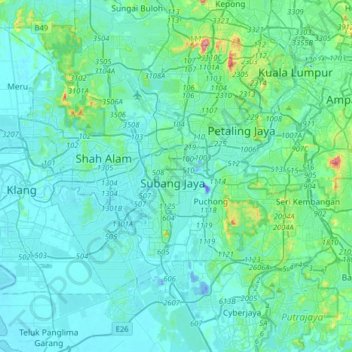
Name: Subang Jaya topographic map, elevation, terrain.
Location: Subang Jaya, Selangor, 47610, Malaysia (2.89675 101.42547 3.21675 101.74547)
Average elevation: 35 m
Minimum elevation: -46 m
Maximum elevation: 323 m
Make a donation
Gear up for your next adventure:
As an Amazon Associate, this site earns from qualifying purchases at no extra cost to you.
Other topographic maps
Click on a map to view its topography, its elevation and its terrain.
Kolam Takungan Banjir Sri Serdang
Malaysia > Selangor > Subang Jaya > Seri Kembangan
Average elevation: 47 m
Kolam Pancing Bukit Lancong
Malaysia > Selangor > Subang Jaya > Kampung Bukit Lanchong
Average elevation: 9 m
Make a donation
Gear up for your next adventure:
As an Amazon Associate, this site earns from qualifying purchases at no extra cost to you.
Make a donation
Gear up for your next adventure:
As an Amazon Associate, this site earns from qualifying purchases at no extra cost to you.
Make a donation
Gear up for your next adventure:
As an Amazon Associate, this site earns from qualifying purchases at no extra cost to you.