Geolocate

Kyiv topographic map

Click on the map to display elevation.

About this map

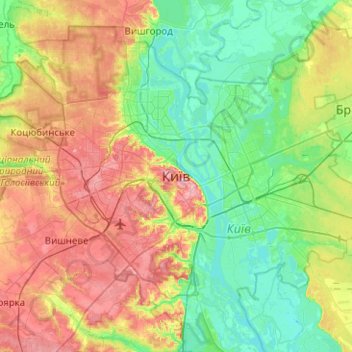
Name: Kyiv topographic map, elevation, terrain.

Location: Kyiv, 1001, Ukraine (50.29003 30.36414 50.61003 30.68414)

Average elevation: 131 m

Minimum elevation: 87 m

Maximum elevation: 210 m

Other topographic maps

Click on a map to view its topography, its elevation and its terrain.

Holosiivskyi District

Ukraine > Kyiv

Average elevation: 128 m

Desnianskyi district

Ukraine > Kyiv

Average elevation: 110 m

Dniprovskyi district

Ukraine > Kyiv

Average elevation: 113 m

Solomianskyi district

Ukraine > Kyiv

Average elevation: 169 m

Shevchenkivskyi district

Ukraine > Kyiv

Average elevation: 157 m

Pecherskyi district

Ukraine > Kyiv

Average elevation: 134 m

Darnytskyi district

Ukraine > Kyiv

Average elevation: 113 m

Obolonskyi district

Ukraine > Kyiv

Average elevation: 136 m

Podilskyi district

Ukraine > Kyiv

Average elevation: 149 m

Sviatoshynskyi district

Ukraine > Kyiv

Average elevation: 152 m

Podilskyi district

Ukraine > Kyiv

Average elevation: 149 m

Shevchenkivskyi district

Ukraine > Kyiv

Average elevation: 157 m

Gear up for your next adventure:

🥾Hiking Boot Waterproofing Wax - Maintain the lifespan of your leather trekking boots
🖼️Topographic Map Art - Decorative 3D-effect posters of famous UK peaks and regions
📱Rugged Phone Cases - Heavy-duty protection for smartphones used as secondary GPS tools
🧤Hiking Gloves - Warm and durable gloves for cold-weather walks
🍲Portable Camping Stoves - Fast-boiling stoves for hot meals on remote topographic survey trips

As an Amazon Associate, this site earns from qualifying purchases at no extra cost to you.