
Make a donation
Gear up for your next adventure:
As an Amazon Associate, this site earns from qualifying purchases at no extra cost to you.
Golan heights topographic map
Click on the map to display elevation.
Make a donation
Gear up for your next adventure:
As an Amazon Associate, this site earns from qualifying purchases at no extra cost to you.
About this map
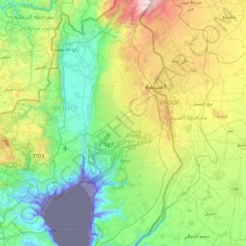
Name: Golan heights topographic map, elevation, terrain.
Location: Golan heights, Golan Subdistrict, North District, Israel (32.75744 35.72470 33.32054 35.74172)
Average elevation: 542 m
Minimum elevation: -218 m
Maximum elevation: 2,213 m
Make a donation
Gear up for your next adventure:
As an Amazon Associate, this site earns from qualifying purchases at no extra cost to you.
Other topographic maps
Click on a map to view its topography, its elevation and its terrain.
Golan Heights
The plateau that Israel controls is part of a larger area of volcanic basalt fields stretching north and east that were created in the series of volcanic eruptions that began recently in geological terms, almost 4 million years ago. The rock forming the mountainous area in the northern Golan Heights,…
Average elevation: 524 m
Sea of Galilee
The Sea of Galilee (Hebrew: יָם כִּנֶּרֶת, Judeo-Aramaic: יַמּא דטבריא, גִּנֵּיסַר, Arabic: بحيرة طبريا), also called Lake Tiberias, Genezareth Lake or Kinneret, is a freshwater lake in Israel. It is the lowest freshwater lake on Earth and the second-lowest lake in…
Average elevation: -67 m
Make a donation
Gear up for your next adventure:
As an Amazon Associate, this site earns from qualifying purchases at no extra cost to you.
Kiryat Shmona
Kiryat Shmona is located in the Finger of the Galilee next to Hula Valley, about 5 kilometres (3 miles) south and 2 km (1 mile) east of the Israel–Lebanon border. Its elevation is about 150 metres (492 feet) above sea level.
Average elevation: 237 m
2236 Mt. Hermon
Israel > North District > Golan Regional Council
Mount Hermon (Arabic: جبل الشيخ or جبل حرمون / ALA-LC: Jabal al-Shaykh ('Mountain of the Sheikh') or Jabal Haramun; Hebrew: הַר חֶרְמוֹן, Har Ḥermōn) is a mountain cluster constituting the southern end of the Anti-Lebanon mountain range. Its summit straddles the border between…
Average elevation: 2,016 m
Make a donation
Gear up for your next adventure:
As an Amazon Associate, this site earns from qualifying purchases at no extra cost to you.
Make a donation
Gear up for your next adventure:
As an Amazon Associate, this site earns from qualifying purchases at no extra cost to you.