
Chicxulub Pueblo topographic map
Interactive map
Click on the map to display elevation.
About this map
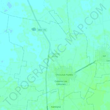
Name: Chicxulub Pueblo topographic map, elevation, terrain.
Location: Chicxulub Pueblo, Yucatán, 97340, Mexico (21.11532 -89.56905 21.19040 -89.47068)
Average elevation: 7 m
Minimum elevation: 4 m
Maximum elevation: 10 m
Other topographic maps
Click on a map to view its topography, its elevation and its terrain.
Chactún (San José Chactún)
Mexico > Yucatán > Maxcanú > Chactún (San José Chactún)
Average elevation: 26 m