
Hunstanton Beach topographic map
Click on the map to display elevation.
About this map
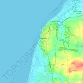
Name: Hunstanton Beach topographic map, elevation, terrain.
Average elevation: 10 m
Minimum elevation: -1 m
Maximum elevation: 65 m
Norfolk trails, hiking, mountain biking, running and outdoor activities
Other topographic maps
Click on a map to view its topography, its elevation and its terrain.
Old Hunstanton Lighthouse
United Kingdom > England > Norfolk > King's Lynn and West Norfolk > Hunstanton > Old Hunstanton
Average elevation: 9 m