
Thank you for supporting this site ❤️
Make a donation
Make a donation
Gear up for your next adventure:
As an Amazon Associate, this site earns from qualifying purchases at no extra cost to you.
Muhlenbach topographic map
Click on the map to display elevation.
Thank you for supporting this site ❤️
Make a donation
Make a donation
Gear up for your next adventure:
As an Amazon Associate, this site earns from qualifying purchases at no extra cost to you.
About this map
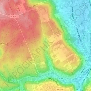
Name: Muhlenbach topographic map, elevation, terrain.
Location: Muhlenbach, Luxembourg, Canton Luxembourg, Luxembourg (49.62492 6.10003 49.65033 6.13249)
Average elevation: 309 m
Minimum elevation: 232 m
Maximum elevation: 390 m
Thank you for supporting this site ❤️
Make a donation
Make a donation
Gear up for your next adventure:
As an Amazon Associate, this site earns from qualifying purchases at no extra cost to you.
Other topographic maps
Click on a map to view its topography, its elevation and its terrain.
Luxembourg City: Old Quarters & Fortifications
Luxembourg > Canton Luxembourg > Luxembourg
Average elevation: 294 m