
Bear topographic map
Click on the map to display elevation.
About this map
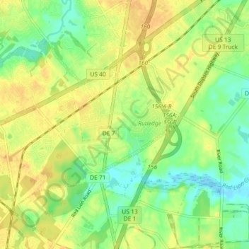
Name: Bear topographic map, elevation, terrain.
Location: Bear, New Castle County, Delaware, 19701, United States (39.59965 -75.71547 39.63755 -75.64359)
Average elevation: 16 m
Minimum elevation: -2 m
Maximum elevation: 29 m
Other topographic maps
Click on a map to view its topography, its elevation and its terrain.
Penn Acres South
United States > Delaware > New Castle County > Wilmington Manor
Average elevation: 12 m
Carousel Park and Equestrian Center
United States > Delaware > New Castle County > Carousel Knoll
Average elevation: 56 m
Cool Spring Reservoir
United States > Delaware > New Castle County > Wilmington
Average elevation: 38 m
Old College Historic District
United States > Delaware > New Castle County > Newark > Oakland
Average elevation: 40 m
Yorklyn
United States > Delaware > New Castle County > Hockessin
Yorklyn is an unincorporated community in northern New Castle County, Delaware, United States. It lies along Delaware Route 82 northwest of the city of Wilmington, the county seat of New Castle County. Its elevation is 174 feet (53 m). It has a post office with the ZIP code 19736.
Average elevation: 91 m
Alapocas Run State Park
United States > Delaware > New Castle County > Blue Ball
Average elevation: 80 m
Quaker Hill
United States > Delaware > New Castle County > Hockessin, Delaware
Average elevation: 94 m
Meeting House Meadows
United States > Delaware > New Castle County > Hockessin
Average elevation: 95 m
Penn Acres South
United States > Delaware > New Castle County > Wilmington Manor
Average elevation: 12 m
Wilmington
United States > Delaware > New Castle County > Wilmington
On the western side of Market Street, the Piedmont topography is rocky and hilly, rising to a point that marks the watershed between the Brandywine River and the Christina River. This watershed line runs along Delaware Avenue westward from 10th Street and Market Street.
Average elevation: 43 m
Runnymeade
United States > Delaware > New Castle County > Hockessin, Delaware > Runnymeade
Average elevation: 92 m