
Czorsztyn topographic map
Interactive map
Click on the map to display elevation.
About this map
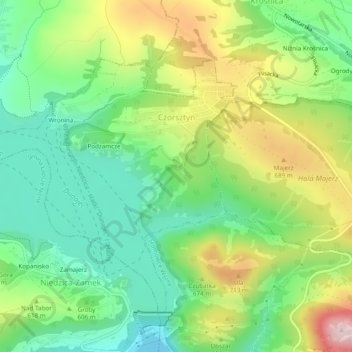
Name: Czorsztyn topographic map, elevation, terrain.
Average elevation: 595 m
Minimum elevation: 481 m
Maximum elevation: 784 m
Other topographic maps
Click on a map to view its topography, its elevation and its terrain.
Obidowa
Poland > Lesser Poland Voivodeship > Nowy Targ County
The summit of Turbacz has a subarctic climate (Köppen Dfc) due to its elevation. The average temperatures are comparable with those found in places in far Northern Europe, such as Alta, Norway, however, the high annual precipitation in combination with the low temperatures places it firmly within the…
Average elevation: 1,117 m
Pieniny
Poland > Lesser Poland Voivodeship > Nowy Targ County > Sromowce Niżne
Average elevation: 632 m