
Margay topographic map
Click on the map to display elevation.
About this map
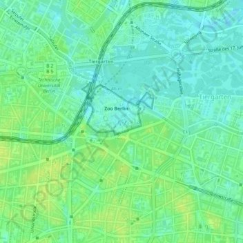
Name: Margay topographic map, elevation, terrain.
Location: Margay, Tiergarten, Mitte, Berlin, 10787, Germany (52.50691 13.34010 52.50712 13.34029)
Average elevation: 40 m
Minimum elevation: 33 m
Maximum elevation: 48 m
Other topographic maps
Click on a map to view its topography, its elevation and its terrain.
Neukölln
Neukölln is on the North European Plain, which is typically characterized by low-lying marshy woodlands with a mainly flat topography. The quarter lies on the geological border between the shallow Weichselian Warsaw-Berlin Urstromtal glacial valley and the northernmost edge of the Teltow young drift ground…
Average elevation: 43 m
Teufelsberg
Teufelsberg was originally thought to be 115 metres (377 ft) high, which placed it at the same elevation as Großer Müggelberg (the summit of Müggelberge), and was the highest point in West Berlin. New measurements show that Teufelsberg is actually 120.1 metres (394 ft) high, making it higher than Großer…
Average elevation: 54 m
Kreuzberg
In contrast to many other areas of Berlin, which were villages before their integration into Berlin, Kreuzberg has a rather short history. It was formed on 1 October 1920 by the Greater Berlin Act, which provided for the incorporation of suburbs and the reorganisation of Berlin into twenty boroughs. The…
Average elevation: 43 m