
Blangpidie topographic map
Interactive map
Click on the map to display elevation.
About this map
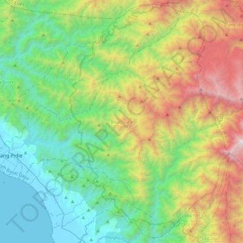
Name: Blangpidie topographic map, elevation, terrain.
Location: Blangpidie, Aceh Barat Daya, Aceh, Indonesia (3.62569 96.80098 3.94804 97.15540)
Average elevation: 1,020 m
Minimum elevation: 0 m
Maximum elevation: 3,382 m
Other topographic maps
Click on a map to view its topography, its elevation and its terrain.
Meureubo
Indonesia > Aceh > Aceh Barat
Meureubo, Aceh Barat, Aceh, 23615, Indonesia
Average elevation: 9 m
Gunung Babahrot
Gunung Babahrot, Babah Rot, Aceh Barat Daya, Aceh, Indonesia
Average elevation: 157 m
Gunung Bandahara
Gunung Bandahara, Putri Betung, Gayo Lues, Aceh, Indonesia
Average elevation: 2,634 m