
Make a donation
Gear up for your next adventure:
As an Amazon Associate, this site earns from qualifying purchases at no extra cost to you.
Adilabad topographic map
Click on the map to display elevation.
Make a donation
Gear up for your next adventure:
As an Amazon Associate, this site earns from qualifying purchases at no extra cost to you.
Adilabad
Adilabad has an average elevation of 264 metres. The district shares its boundaries with Nirmal districts of Telangana to the south, Komaram Bheem district on the east, with Nanded on the west and Yavatmal and Chandrapur districts of Maharashtra to the north.
Make a donation
Gear up for your next adventure:
As an Amazon Associate, this site earns from qualifying purchases at no extra cost to you.
About this map
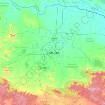
Name: Adilabad topographic map, elevation, terrain.
Average elevation: 310 m
Minimum elevation: 196 m
Maximum elevation: 626 m
Make a donation
Gear up for your next adventure:
As an Amazon Associate, this site earns from qualifying purchases at no extra cost to you.