Geolocate

Schermbeck topographic map

Interactive map

Click on the map to display elevation.

About this map

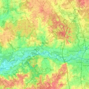
Name: Schermbeck topographic map, elevation, terrain.

Location: Schermbeck, Kreis Wesel, North Rhine-Westphalia, 46514, Germany (51.63102 6.69973 51.74883 6.94065)

Average elevation: 47 m

Minimum elevation: 22 m

Maximum elevation: 73 m

Other topographic maps

Click on a map to view its topography, its elevation and its terrain.

Voerde (Niederrhein)

Germany > North Rhine-Westphalia > Kreis Wesel

Voerde (Niederrhein), Kreis Wesel, North Rhine-Westphalia, 46562, Germany

Average elevation: 27 m

Labbeck

Germany > North Rhine-Westphalia > Kreis Wesel

Labbeck, Sonsbeck, Kreis Wesel, North Rhine-Westphalia, 47665, Germany

Average elevation: 43 m

Sonsbeck

Germany > North Rhine-Westphalia > Kreis Wesel

Sonsbeck, Kreis Wesel, North Rhine-Westphalia, 47665, Germany

Average elevation: 31 m

Moers

Germany > North Rhine-Westphalia > Kreis Wesel

Moers, Kreis Wesel, North Rhine-Westphalia, Germany

Average elevation: 28 m

Wesel

Germany > North Rhine-Westphalia > Kreis Wesel

Wesel, Kreis Wesel, North Rhine-Westphalia, Germany

Average elevation: 26 m