
Gorjões topographic map
Interactive map
Click on the map to display elevation.
About this map
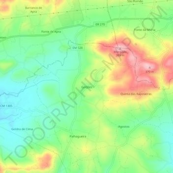
Name: Gorjões topographic map, elevation, terrain.
Location: Gorjões, Santa Bárbara de Nexe, Faro, 8005-440, Portugal (37.11500 -7.97135 37.15500 -7.93135)
Average elevation: 251 m
Minimum elevation: 178 m
Maximum elevation: 366 m
Other topographic maps
Click on a map to view its topography, its elevation and its terrain.
Azinhal e Amendoeira
Azinhal e Amendoeira, Conceição e Estoi, Faro, 8005-414, Portugal
Average elevation: 187 m