Geolocate

Senoia topographic map

Click on the map to display elevation.

About this map
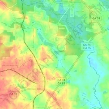
Name: Senoia topographic map, elevation, terrain.

Location: Senoia, Coweta County, Georgia, United States (33.28713 -84.59043 33.34199 -84.52233)

Average elevation: 253 m

Minimum elevation: 220 m

Maximum elevation: 297 m

Other topographic maps

Click on a map to view its topography, its elevation and its terrain.
Newnan Pines

United States > Georgia > Coweta County

Average elevation: 278 m

Sargent

United States > Georgia > Coweta County

Average elevation: 247 m

Arnco Mills

United States > Georgia > Coweta County

Average elevation: 256 m

Lambert Field

United States > Georgia > Coweta County > Newnan

Average elevation: 285 m

Gear up for your next adventure:

📐Altimeters & Barometers - Tools for measuring altitude and air pressure
🍳Camping Stoves - Compact stoves for outdoor cooking
👟Men's Trail Running Shoes - Lightweight grip for fast movement over topographic contours
🧭Orienteering Compasses - Accurate compasses for map-based navigation
🔦Waterproof LED Headlamps - Hands-free lighting for evening treks and emergency navigation

As an Amazon Associate, this site earns from qualifying purchases at no extra cost to you.