
Make a donation
Gear up for your next adventure:
As an Amazon Associate, this site earns from qualifying purchases at no extra cost to you.
Eghlid topographic map
Click on the map to display elevation.
Make a donation
Gear up for your next adventure:
As an Amazon Associate, this site earns from qualifying purchases at no extra cost to you.
Eghlid
Eqlid is located 22 km west of the Expressway between Isfahan and Shiraz. The population of Eghlid is about 45,000 (2011). It is located close to the mountain chain Zagros and is one of the highest elevations (a mountain peak known as Bel) among Iran cities (2250 meters). It is also close to the desert city of Abarqu, making it a city in the border of high mountain and desert. It has a dry and cold weather, and some of its mountain peaks are covered by snow throughout the year. It is an agriculture city and its main products are wheat, barley, potato and fruits like grapes, walnut, apple, and pear. Its main road is Emam Khomeini Boulevard.
Make a donation
Gear up for your next adventure:
As an Amazon Associate, this site earns from qualifying purchases at no extra cost to you.
About this map
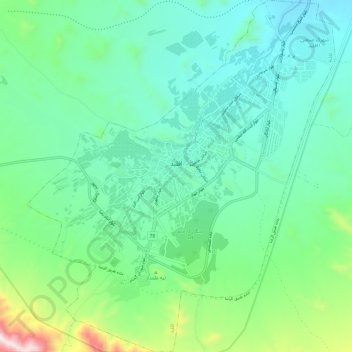
Name: Eghlid topographic map, elevation, terrain.
Average elevation: 2,310 m
Minimum elevation: 2,115 m
Maximum elevation: 2,984 m
Make a donation
Gear up for your next adventure:
As an Amazon Associate, this site earns from qualifying purchases at no extra cost to you.
Other topographic maps
Click on a map to view its topography, its elevation and its terrain.