Geolocate

Rude topographic map

Click on the map to display elevation.

About this map

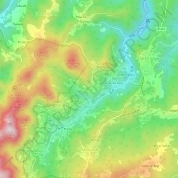
Name: Rude topographic map, elevation, terrain.

Location: Rude, Grad Samobor, Zagreb County, Croatia (45.75118 15.65046 45.79101 15.69561)

Average elevation: 406 m

Minimum elevation: 196 m

Maximum elevation: 708 m

Other topographic maps

Click on a map to view its topography, its elevation and its terrain.

Beder

Croatia > Zagreb County > Grad Samobor

Average elevation: 414 m

Dubranec

Croatia > Zagreb County > City of Velika Gorica

Average elevation: 177 m

Dubranec

Croatia > Zagreb County > City of Velika Gorica

Average elevation: 177 m

Prigorje Brdovečko

Croatia > Zagreb County

Average elevation: 161 m

Vernari

Croatia > Zagreb County > Gornji Stupnik

Average elevation: 129 m

Donja Drenova

Croatia > Zagreb County

Average elevation: 215 m

Bregana

Croatia > Zagreb County > Bregana

Average elevation: 190 m

Klingino brdo

Croatia > Zagreb County > Veliki Vrh

Average elevation: 351 m

Trstenik

Croatia > Zagreb County

Average elevation: 200 m

Gear up for your next adventure:

🦶Anti-Blister Balms - Protect your feet before long topographic expeditions
📐Altimeters & Barometers - Tools for measuring altitude and air pressure
🧢Thermal Beanie Hats - Prevent heat loss from the head in windy summit conditions
🖼️Topographic Map Art - Decorative 3D-effect posters of famous UK peaks and regions
🔭Compact Hiking Binoculars - Lightweight optics for scouting terrain and spotting wildlife

As an Amazon Associate, this site earns from qualifying purchases at no extra cost to you.