
Madikere topographic map
Interactive map
Click on the map to display elevation.
About this map
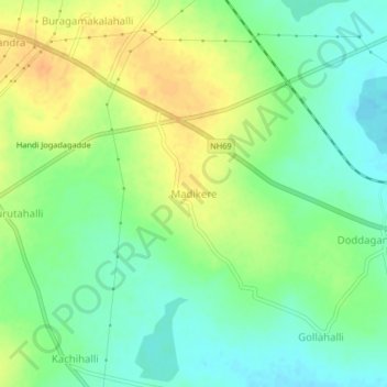
Name: Madikere topographic map, elevation, terrain.
Average elevation: 853 m
Minimum elevation: 837 m
Maximum elevation: 872 m
Other topographic maps
Click on a map to view its topography, its elevation and its terrain.
Chintamani
India > Karnataka > Chintamani taluk
Chintamani lies in the southeast of the South Indian state of Karnataka. It is in the heart of the Mysore Plateau at an average elevation of 865 m (2,838 ft). The Taluk geographically lies between 78°12′36″N 13°16′38″E / 78.21000°N 13.27722°E / 78.21000; 13.27722 and 77°51′39″N…
Average elevation: 886 m