
Make a donation
Gear up for your next adventure:
As an Amazon Associate, this site earns from qualifying purchases at no extra cost to you.
Torbole topographic map
Click on the map to display elevation.
Make a donation
Gear up for your next adventure:
As an Amazon Associate, this site earns from qualifying purchases at no extra cost to you.
About this map
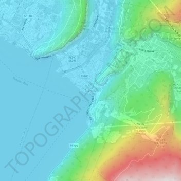
Name: Torbole topographic map, elevation, terrain.
Average elevation: 242 m
Minimum elevation: 53 m
Maximum elevation: 987 m
Make a donation
Gear up for your next adventure:
As an Amazon Associate, this site earns from qualifying purchases at no extra cost to you.
Other topographic maps
Click on a map to view its topography, its elevation and its terrain.
Fiume Brenta
Italy > Trentino-Alto Adige/Südtirol > Provincia di Trento > Caldonazzo > Brenta
Average elevation: 470 m
Make a donation
Gear up for your next adventure:
As an Amazon Associate, this site earns from qualifying purchases at no extra cost to you.
San Giorgio
Italy > Trentino-Alto Adige/Südtirol > Provincia di Trento > Arco > San Giorgio
Average elevation: 93 m
Castello San Giovanni
Italy > Trentino-Alto Adige/Südtirol > Provincia di Trento > Baitoni
Average elevation: 568 m
Make a donation
Gear up for your next adventure:
As an Amazon Associate, this site earns from qualifying purchases at no extra cost to you.
Make a donation
Gear up for your next adventure:
As an Amazon Associate, this site earns from qualifying purchases at no extra cost to you.
Gruppo del Catinaccio
Italy > Trentino-Alto Adige/Südtirol > Provincia di Trento
Average elevation: 1,863 m
Tione di Trento
Italy > Trentino-Alto Adige/Südtirol > Provincia di Trento > Tione di Trento
Average elevation: 1,248 m
Calliano
Italy > Trentino-Alto Adige/Südtirol > Provincia di Trento > Calliano
Average elevation: 609 m
Make a donation
Gear up for your next adventure:
As an Amazon Associate, this site earns from qualifying purchases at no extra cost to you.